
Current wildfire-related air quality
This page is updated every Wednesday between June and October, or more frequently if the local air quality situation changes.
Last updated Wednesday, August 19, 2026.
Please note that this information is a snapshot in time and may not reflect current risk levels. For real-time data, please see:
- Small sensor air monitors around our region – see AQmap (unbc.ca)
- 72-hour Smoke Forecast — see Environment Canada (weather.gc.ca/firework)
- Active Wildfires — see Canadian Wildland Fire Information System | Interactive map (nrcan.gc.ca)
Current Air Quality
This map shows the Particulate Matter (PM2.5) levels from various air monitors in Northeastern Ontario and surrounding areas as of Wednesday, August 19, 2026. [1,2]
Note: Factors such as differences in calibration, weather conditions, and the location and placement of the monitors can influence the accuracy and reliability of the measurements.
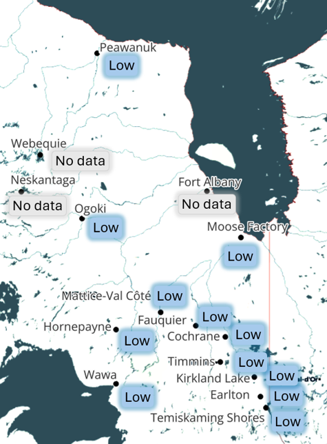
| Community | Air quality level |
| Cochrane | Low |
| Earlton | Low |
| Fauquier | Low |
| Fort Albany | No data |
| Haileybury | Low |
| Hornepayne | Low |
| Kirkland Lake | Low |
| Mattice-Val Côté | Low |
| Moose Factory | Low |
| Neskantaga | No data |
| Ogoki | Low |
| Peawanuck | Low |
| Timmins | Low |
| Wawa | Low |
| Webequie | No data |
AQI and health effects
The table below shows the relationship between hourly PM2.5 concentrations shown on the AQMap, the AQHI+ levels and associated health messaging for general and at-risk populations.
| Health Risk | PM2.5* | AQHI+** | Health Messages | ||
|---|---|---|---|---|---|
| People at Higher Risk | General Population | ||||
| Low | <30 | 1–3 | Enjoy your usual outdoor activities. | Ideal air quality for outdoor activities. | |
| Moderate | 31–60 | 4–6 | Consider reducing or rescheduling strenuous activities outdoors if you are experiencing symptoms. | No need to modify your usual outdoor activities unless you experience symptoms such as coughing and throat irritation. | |
| High | 61–100 | 7–10 | Reduce or reschedule strenuous activities outdoors. Children and the elderly should also take it easy. | Consider reducing or rescheduling strenuous activities outdoors if you experience symptoms such as coughing and throat irritation. | |
| Very High | 101+ | Above 10 | Avoid strenuous activities outdoors. Children and the elderly should also avoid outdoor physical exertion. | Reduce or reschedule strenuous activities outdoors, especially if you experience symptoms such as coughing and throat irritation. | |
* PM2.5µg/m-3 (1 hr) ** Air Quality Health Index+
What is in wildfire smoke?
Wildfire smoke is made up of a mixture of gases and very small particles that are produced when wood and other organic matter burn. The small particles in wildfire smoke also contain other types of air pollution and have been linked to serious health effects. Smoke also contains toxic gases like carbon monoxide that can be harmful to your health.
Smoke particles are small and can get deep into your lungs and may be absorbed into the bloodstream.
Who is at risk?
Each person reacts differently to smoke; some are at higher risk of experiencing adverse effects. People in the following groups should reduce their exposure to smoke:
- Children
- Seniors
- Pregnant individuals
- Those with lung disease (asthma or other chronic respiratory diseases)
- Those with heart disease
- Smokers
- People experiencing homelessness.
- Those who work outdoors
Keep an eye on your neighbours, family and friends, and people in your care who may be more susceptible to wildfire smoke. Encourage them to seek help if needed and give them tips to protect themselves.
Protect yourself and minimize the health effects of wildfire smoke
- Stay out of the smoke as much as possible.
- If it looks smoky outside, it is best to stay indoors with the windows closed whenever possible. If the indoor temperature rises to an uncomfortable level, opening the window may be necessary to avoid heat exhaustion. Ideally, use air conditioning, if it is available, or indoor fans to keep cool, and be sure to drink plenty of water to stay hydrated.
- Reduce or avoid outdoor physical activity when possible.
- If you have an air cleaner that will reduce levels of small particles in indoor air, use it and stay in the room where it is located, where possible.
- Use air conditioning (on the recirculate setting) in cars and keep windows closed. Remember, vehicles should never be run in an enclosed space like a garage.
- Avoid using smoke-producing appliances such as wood stoves and even candles.
- Limit smoking tobacco as much as possible – smoking puts added stress on your lungs and on those around you.
- If you have asthma or other respiratory conditions, be vigilant about avoiding smoke and take your prescribed medicine. Speak with your health care provider to get the specific advice that is right for you.
Take care of your mental health and well-being
Pay special attention to your mental health and that of those in your care. Anyone who is having trouble coping with symptoms of stress, anxiety or depression should seek help from a health professional. These resources are available free of cost to anyone experiencing mental health problems. Don't be afraid to reach out if you need help:
These monitors were provided by Environment and Climate Change Canada and are generously hosted and maintained by various community partners.
- The health risk level represents a summarized value from PurpleAir monitors, which measure particulate matter. The recommendations are from the Air Quality Health Index (AQHI) scale, which uses a combination of particulate matter (PM2.5), ozone and nitrogen dioxide; however, only data on particulate matter is available for our health unit area.
- Source: Environment and Climate Change Canada - Meteorological Services of Canada in collaboration with the University of Northern British Columbia. Mapping tool. https://cyclone.unbc.ca/aqmap